Wednesday, August 30, 2017
Map Shows Harvey's Impact, Using Commercial Fleet Activity
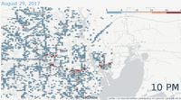 As things finally start drying out in Houston, the impact and scope of Harvey on the city's business and commerce has been unclear. A new map, released by telematics provider Geotab, shows exactly how much Harvey has reduced commercial activity in Houston. Geotab released an animated map which illustrates commercial trucking and fleet activity before, during, and after Harvey, showing the geographic scope of Harvey's devastation on travel within Houston, as vehicles cleared the roads or became stuck in high waters. Geotab says it has its devices in thousands of vehicles in the Houston area.